- The most recent issue to be published was 50(3)
- For further information, please see Publishing/Despatch Schedule
- Database last updated on Sun, 18 Feb 2024 09:37:35 +0000
Contents of Cave & Karst Science 41(1)
This page may take a few seconds
to load. Please wait ...
- Cave and Karst Science (iv + 48pp)
(PDF 7.5MB)
  Individual articles may be available below Individual articles may be available below
- GUNN, John and David LOWE (eds.). (2014). Cave and Karst Science
41(1).
Buxton: British Cave Research Association.
ISSN 1356-191X. iv + 48pp, A4, with photos, maps and diagrams.
This issue has a cover date of 2014 (April) and was published in May 2014.
- The Transactions of the British Cave Research Association
- Layman's Summaries
-
Some of the articles in this issue are explained in a layman's summary.
Look for the 'Summary' icons below, or download the article from here:
HTML 10KB
 
- Front cover photo (page i)
(PDF 358KB)
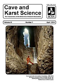
- by Paul DEAKIN.
Alum Pot, west of the hamlet of Selside in Ribblesdale, is a classic Yorkshire Dales open-shaft cave system, commencing as an impressive surface gash up to some 37m in length and reaching 10m wide. [...] Just visible, high in the chasm, is the Bridge, a huge wedged boulder that spans the shaft, and the right-hand wall of the rift shows evidence of the presence of the Alum Pot Fault, a strike-slip fault zone that has guided the development of the open shaft and some parts of the related passage systems at higher level. The paper by Lowe and Waters in this Issue discusses fault guidance of cave development along with other geological influences. (Photo: Paul Deakin, FRPS).
-
- Notes for Contributors (page ii)
(PDF 248KB)
-
- Contents (p1)
(PDF 320KB)
-
- Editorial Advisory Board (p48)
(PDF 189KB)
-
- Editorial (p2)
(PDF 161KB)
- by David LOWE and John GUNN.
-
- Description and environmental monitoring of Hokkai Cave in northern Japan (pp3-12)
(PDF 1.9MB)
- by Wataru HASEGAWA, Takanobu SAWAGAKI, Kazuomi HIRAKAWA, Yumiko WATANABE and Takahiro TAGAMI.
Hokkai Cave was discovered in 2006 in south-western Hokkaido, northern Japan, and has been conserved in its natural condition. This paper reports the results of a basic speleological study of the cave's environment conducted during 2006 to 2009, including a geomorphological survey, monitoring of cave air temperature, airflow and groundwater currents, and an initial interpretation of the cave's speleogenesis. These basic cave data are important to help improve palaeo-climatic speleothem sample selection, because speleothem geochemistry is also controlled by cave geometry and micro-meteorology. Hokkai Cave is a 479.8m-long, zigzag, horizontal system, with two entrances. The cave floor is mainly covered with clay, gravels and breakdown blocks. An underground river flows in the centre of the cave and a dry riverbed, and many springs and dolines are present around the cave.
Pure white stalagmites in the cave are possibly suitable for use in Asian Summer Monsoon reconstruction studies. Air temperature in the inner cave (more than 15m from entrances) was stable throughout the year (7.5 to 7.7°C); in contrast, air temperature near the entrance was variable because of the influence of the outside air temperature. Inversion of airflow direction is driven by the air temperature gradient between the inside and the outside of the cave. When air temperature inside is warmer than outside, air flows from Ent. U (upper) to Ent. L (lower) and from Ent. U to the inside. When air temperature outside is warmer than inside, air flows from Ent. L to Ent. U and from the inner cave to Ent. U. These results agree with findings from previous studies. Inversion of airflow direction also affects the variation pattern of air temperature near the entrances. Monitoring also indicates that the underground river is usually dry except after heavy rainfall or snow melting.
Summary: For layman's summary see
HTML 10KB
Classification: Paper.
Date: Received: 11 November 2013; Accepted: 25 February 2014.
- Bibliograph: HASEGAWA, Wataru; Takanobu SAWAGAKI, Kazuomi HIRAKAWA, Yumiko WATANABE and Takahiro TAGAMI. (2014). Description and environmental monitoring of Hokkai Cave in northern Japan. Cave and Karst Science 41(1), pp3-12.
-
- Geological influences on cave origin and development in the Yorkshire Dales, UK (pp13-35)
(PDF 3.4MB)
- by David J LOWE and Colin N WATERS.
The Inception Horizon Hypothesis of cave origin encompasses geology-centred views of when, why and how primitive permeability was imprinted within mainly karstic limestone sequences. Potentially, the earliest processes affect unconsolidated or partially consolidated sediment during early diagenesis and are inevitably related to lithological contrasts. Such contrasts eventually become recognizable as specific horizons, to the extent that these 'inception horizons' become an intrinsic part of the preserved rock succession during syngenetic and mesogenetic diagenesis. The horizons provide the key to the establishment of the earliest extended, low efficiency hydraulic gradients within rocks that were initially virtually impermeable.
With the onset of telogenetic conditions following uplift and tectonism the early role of 'inception horizons' continues under less confined or unconfined conditions, but with added scope for the involvement of tectonic fractures (broadly faults and joints). These can provide 'inception links', enabling establishment of geometrically more complex but also more efficient hydraulic gradients. Whereas a newly uplifted karstic succession can include the imprints of several vertically-stacked 'inception horizons' linked to depositional cyclicity (sensu lato), how these imprints help to guide aspects of later cave development depends upon the three-dimensional relationships of 'inception horizons' and 'inception links' (folds and fractures) and upon how the developing landscape interacts with them. The still partly theoretical concept is illustrated with examples from the Yorkshire Dales.
Summary: For layman's summary see
HTML 10KB
Classification: Paper.
Date: Received: 10 February 2013; Accepted: 04 March 2014; Revised in proof: 23 April 2014. Online version 2: uploaded 4 June 2014 (captions [missing in online version only] to Figs 3 and 7 inserted; Acknowledgements updated).
Keywords: Inception Horizon Hypothesis; cave origin; inception horizon; inception link; Yorkshire Dales.
- Bibliograph: LOWE, David J and Colin N WATERS. (2014). Geological influences on cave origin and development in the Yorkshire Dales, UK. Cave and Karst Science 41(1), pp13-35.
-
- The Dark Star of Baisun-tau: a history of cave exploration in southern Uzbekistan, 1990–2013 (pp36-41)
(PDF 1.5MB)
- by Evgenii A TSURIKHIN, Sebastian F M BREITENBACH, Vadim L LOGINOV and Antonina A VOTINTSEVA.
Very little is known about the karst and caves in southern Uzbekistan, where some of the deepest caves in Asia have been discovered. In particular, the limestone plateau of the Baisun-tau mountain range has a tremendous potential for exploration. This region is also important for palaeoclimate studies, as it is situated in the transition zone between the Westerlies and the Indian Summer Monsoon. For more than 15 years Festival'naya Cave, now the Festival'naya-Ledopadnaya cave system, was the main focus of cavers' attention. Then, in 2011 the great potential of Dark Star Cave was revealed, after extensive new discoveries were made. Since then, additional expeditions with international teams of cavers, led by the Ekaterinburg Speleological Club and with the support of the Speleological Association of the Urals (SAU, Russia), have continued the exploration of these unique high altitude caves of the Baisun-tau. Both the length and depth of Dark Star have been increased almost two-fold every year. So far, six entrances and 9,537m of surveyed passages have been discovered to a depth of -858m, and Dark Star has now become the focus of exploration for expeditions to the area.
Summary: For layman's summary see
HTML 10KB
Classification: Report.
Date: Received: 27 December 2013; Accepted: 14 March 2014.
- Bibliograph: TSURIKHIN, Evgenii A; Sebastian F M BREITENBACH, Vadim L LOGINOV and Antonina A VOTINTSEVA. (2014). The Dark Star of Baisun-tau: a history of cave exploration in southern Uzbekistan, 1990–2013. Cave and Karst Science 41(1), pp36-41.
-
- Processes affecting aerosol concentrations in Gough's Cave, Cheddar Gorge, UK (pp42-47)
(PDF 797KB)
- by Jonathan DREDGE, Ian J FAIRCHILD, Roy M HARRISON and John GUNN.
Results are presented from environmental monitoring over seasonal timescales in Gough's Cave, Cheddar Gorge, UK as a component of cave process research. Pronounced diurnal cycles in cave air pCO2, temperature and aerosols are observed in summer (15/08/12 to approx. 12/09/12) and are attributed to the dominance of anthropogenic influences. The cycles diminish in the winter (end-September onwards) when the combination of reduced visitor numbers and increased cave ventilation allows natural processes to dominate. The reversal of the internal-external thermal gradient during mid-September coincides with an increase in the baseline concentration of aerosols. Aerosol baseline data allow the identification of distinct seasonal modes providing a greater insight into environmental processes within the cave than more established metrics such as pCO2 and temperature alone.
Summary: For layman's summary see
HTML 10KB
Classification: Paper.
Date: Received: 17 May 2013; Accepted: 04 March 2014.
Keywords: Aerosols; cave ventilation; cave monitoring; cave environment; cave anthropogenic influences.
- Bibliograph: DREDGE, Jonathan; Ian J FAIRCHILD, Roy M HARRISON and John GUNN. (2014). Processes affecting aerosol concentrations in Gough's Cave, Cheddar Gorge, UK. Cave and Karst Science 41(1), pp42-47.
-
- Research Fund and Grants (page iii)
(PDF 593KB)
-
- Back cover photos (page iv)
(PDF 317KB)
- A selection of images from the Central Karst System of Hodja-Gur-Gur-Ata in the Baysun-Tau mountain range in southern Uzbekistan [see the report by Tsurikhin et al. in this Issue]. See contents page for list of photos and credits.
-

| Please ignore this information box: we are doing some maintenance
work today.
remote: Array
(
)
local:
|
|

View Contents:
BCRA is a UK registered charity and is a constituent body of
the British Caving Association,
undertaking charitable activities on behalf of the BCA.
BCRA publishes a range of periodicals and books.
Click here for further information.
|
Searching
To Search our pages using Google, type a search
string in the box at the top of the page and hit your Return key
You can also search our publications catalogue at the British Caving Library
The CREG Journal Search Engine is a new, powerful search engine which will, sometime, be extended
to cover Cave & Karst Science. We have a keyword search facility on our Cave Science Indexes pages but this may be rather out-of-date.
|
For staff use: Link to Database
Show/Hide
download figures next to each item (if available and non-zero; you might need to refresh page first). Counters last
reset on Thu 03-Jan-2019 17:29:28 +00:00. The figures are non-unique
click-throughs.
|


