- The most recent issue to be published was 50(3)
- For further information, please see Publishing/Despatch Schedule
- Database last updated on Sun, 18 Feb 2024 09:37:35 +0000
Contents of Cave & Karst Science 36(1)
This page may take a few seconds
to load. Please wait ...
- Cave and Karst Science (iv + 32pp)
(PDF 32.8MB)
  Individual articles may be available below Individual articles may be available below
- GUNN, John and David LOWE (eds.). (2009). Cave and Karst Science
36(1).
Buxton: British Cave Research Association.
ISSN 1356-191X. iv + 32pp, A4, with photos, maps and diagrams.
This issue has a cover date of 2009 (April) and was published in April 2010.
- The Transactions of the British Cave Research Association
- Layman's Summaries
-
Some of the articles in this issue are explained in a layman's summary.
Look for the 'Summary' icons below, or download the article from here:
PDF 479KB
 
- Front cover photo (page i)
(PDF 3.6MB)
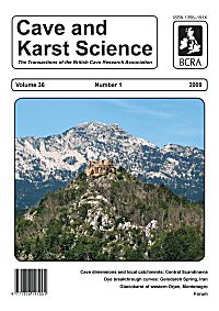
- by Uros STEPISNIK.
Part of the glaciated and karstified Orjen massif in Montenegro. The distant mountain is Zubački kabao, the highest peak of the massif. In the middle distance the hill known as Stražnik is the site of a ruined fortress, an Austro-Hungarian defensive outpost on the former frontier with the Ottoman Empire. See Paper by Stepišnik et al. in this Issue. Original photograph by Uroš Stepišnik.
-
- Notes for Contributors (page ii)
(PDF 251KB)
-
- Contents (p1)
(PDF 441KB)
-
- Notice of BCRA Field Meeting 8 Sept 2010 (p2)
(PDF 416KB)
-
- Editorial (p3)
(PDF 367KB)
- by Dave LOWE, John GUNN and David GIBSON.
-
- William Stanton, obituary (p4)
(PDF 220KB)
- by Andy FARRANT.
-
- Periodic breakthrough curve of tracer dye in the Gelodareh Spring, Zagros, Iran (pp5-10)
(PDF 5.2MB)
- by Haji KARIMI and Javad ASHJARI.
The Patagh Dam is under construction in the Kermanshah province in the west of Iran. The right abutment of the dam is located on Ilam-Sarvak limestone, which has the potential of karstification. This limestone is drained by several springs including Gelodareh Spring. In order to study possible leakage through the dam, a dye tracing test was organized in borehole PC208 near the dam. The recession coefficients and hydrochemical data of the Gelodareh Spring show that the flow regime of the area is of diffuse type.
The dye appeared in the water samples from borehole PC206 and Gelodareh Spring, which are located downstream of the dam. This demonstrates a hydraulic connection between the injection well and these points. Therefore, there is the potential for seepage through the right abutment of the dam. The measured mean flow velocity to borehole PC206 (0.86 m/h) indicates a diffuse flow regime. The breakthrough curve of the Gelodareh Spring shows multiple peaks without significant tail except the last one. Additionally, the high flow velocity (11.8 m/h) is at odds with a diffuse flow regime. The ambiguous behaviour of the dye breakthrough curve of the Gelodareh Spring is explained by a combination of siphon and diffuse flow systems. Existence of a siphon flow system explains the multiple periodic peaks of the breakthrough curve and the lack of tails. The tail on the last peak is the result of diffuse flow system. A neck, close to the spring or the main conduit, which conveys water to the spring, might be causing the pseudo-steady state behaviour of spring discharge and diminishes the periodic discharge fluctuation, which is created by a siphon. It is probable that the siphon level is situated in the zone of water level fluctuation.
Summary: For layman's summary see
PDF 479KB
Classification: Paper.
Date: Received 22 July 2009; Accepted 29 December 2009.
Keywords: dye tracing, karst, breakthrough curve, Patagh Dam, siphon.
- Bibliograph: KARIMI, Haji and Javad ASHJARI. (2009). Periodic breakthrough curve of tracer dye in the Gelodareh Spring, Zagros, Iran. Cave and Karst Science 36(1), pp5-10.
-
- Relationships between cave dimensions and local catchment areas in Central Scandinavia: implications for speleogenesis (pp11-20)
(PDF 4.0MB)
- by Trevor FAULKNER.
The caves formed in the Caledonide metalimestones of Central Scandinavia are identified as occurring in three cave hydrological classes that are randomly intermingled with each other both geographically and altitudinally: relict, mainly vadose (MV) and combination caves. The morphology of the relict caves shows that they were enlarged phreatically. Their dimensions of length, cross-section and volume are unrelated to their local catchment area, whose mean size is only 2.6km2. Indeed, large relict caves may be found near ridge tops, and their mean cross-section to catchment area ratio (XS/CA) is as large as 20.3m2km-2. MV caves contain active stream passages and sumps without significant phreatic upper levels or passages. Although there is no simple relationship between their mean dimensions and their local catchment area, which has a mean size of 4.7km2, their mean XS/CA ratio is only 2.8m2km-2. However, their maximum dimensions are constrained by the logarithm of catchment area. The combination caves contain relict phreatic (and, more rarely, relict vadose) passages that lie above an active vadose streamway and they have mean dimensions significantly larger than those of both relict and MV caves. Their mean CA is 4.6km2 (close to that of the other active cave class) and their mean XS/CA ratio is 11.6m2km-2, which is intermediate between relict caves and MV caves.
These observations suggest that the active vadose passages developed during the present conditions of the Holocene, with dimensions related to the flow-rates of present allogenic recharge, as supported by likely entrenchment and waterfall recession rates. In contrast, the relict phreatic passages probably enlarged when the caves were submerged by flowing glacial meltwater that was less related to present catchment area, during a previous deglaciation phase. Most relict caves and the whole set of MV caves seem to have each separately experienced only one phase of cave enlargement after inception, with phreatic development favoured at valley shoulder and ridge cave locations and vadose development favoured at valley floors with large catchments. The larger dimensions and greater complexity of the combination caves indicate that they are more representative of the full range of enlargement opportunities that were available during the evolution of their local topography during one or more full cycles of glaciation, deglaciation and interglaciation.
Summary: For layman's summary see
PDF 479KB
Classification: Paper.
Date: Received 18 November 2009; Accepted 07 January 2010.
Keywords: Caledonide, marble, Scandinavia, dimensions, catchment, speleogenesis, mainly vadose, relict phreatic, deglaciation, Holocene.
- Bibliograph: FAULKNER, Trevor. (2009). Relationships between cave dimensions and local catchment areas in Central Scandinavia: implications for speleogenesis. Cave and Karst Science 36(1), pp11-20.
-
- Glaciokarst of western Orjen, Montenegro (pp21-28)
(PDF 10.9MB)
- by Uros STEPISNIK, Mateja FERK, Blaz KODELJA, Goran MEDENJAK, Andrej MIHEVC, Karel NATEK and Manja ZEBRE.
The Orjen Massif is situated in the southeastern part of the Dinaric Mountains on the border between Montenegro, Croatia, and Bosnia and Herzegovina. Its highest peak is Zubački kabao (1894m). Detailed geomorphological mapping was used to facilitate reconstruction of the extent of ice advance during the last glacial maximum within four valley glaciers in western Orjen. The length of the glaciers in the valleys was up to 4km. Glaciation of the karstic surface resulted in a series of features that are typical of glaciokarst. In the upper of the valleys there are a number of over-deepened cirques, kotlič and cave entrances. In the accumulation-dominant areas of the glaciers distinct lateral-terminal moraine complexes were formed and proglacial fans exhibit features indicative of formation by multiple glacial floods that were an indirect result of the contemporary functioning of the glacial and karstic geomorphic system. By studying the up-valley limits of lateral moraines and applying an altitude-ratio methodology, the equilibrium line altitude of the glaciers during their maximum extent was determined at an elevation of 1325m.
Classification: Paper.
Date: Received 07 December 2009 ; Accepted 03 February 2010.
Keywords: Dinaric karst, Orjen, karst, glaciation, ELA, glacial outburst.
- Bibliograph: STEPISNIK, Uros; Mateja FERK, Blaz KODELJA, Goran MEDENJAK, Andrej MIHEVC, Karel NATEK and Manja ZEBRE. (2009). Glaciokarst of western Orjen, Montenegro. Cave and Karst Science 36(1), pp21-28.
-
- Book Review (p29)
(PDF 939KB)
- A response to Trevor Shaw's Book Review of Hydromythology and the Ancient Greek World: An Earth Science Perspective Emphasizing Karst Hydrology [Cave and Karst Science, Vol.35/3, p.120.
Classification: Forum.
-
- Correspondence (pp29-30) For download see previous item
- by John CORDINGLEY.
Spherical clasts from boulder-choked phreatic lifts.
Classification: Forum.
-
- Thesis and dissertation abstracts (pp30-31)
(PDF 860KB)
- 1) Moseley, Gina (2009), Mid to Late Quaternary sea level change of the circum-Caribbean Region. PhD: University of Bristol.
2) Lloyd, Dewi (2008), Measurement of radon and its progeny in a cave environment in North Wales. MSc dissertation: University of Birmingham.
Classification: Forum.
-
- Book Reviews (pp31-32)
(PDF 1.1MB)
- 1) The Metalliferous Mines of Cartmel and South Lonsdale. By Max Moseley (2010). Published by The Northern Mine Research Society, Nelson, Lancashire, UK.
2) Caves and Karst of the USA. Edited by Arthur N Palmer and Margaret V Palmer (2009). Published by National Speleological Society, Huntsville, Alabama.
3) International Journal of Speleology Volume 39(1), January 2010. List of contents.
Classification: Forum.
-
- Research Fund and Grants (page iii)
(PDF 239KB)
-
- Back cover photos (page iv)
(PDF 8.0MB)
- by Karel NATEK, Uros STEPISNIK and Jure TICAR.
A montage of images showing aspects of the glaciokarst landscape in the high coastal karst of Montenegro. See contents page for descriptions.
-

| Please ignore this information box: we are doing some maintenance
work today.
remote: Array
(
)
local:
|
|

View Contents:
BCRA is a UK registered charity and is a constituent body of
the British Caving Association,
undertaking charitable activities on behalf of the BCA.
BCRA publishes a range of periodicals and books.
Click here for further information.
|
Searching
To Search our pages using Google, type a search
string in the box at the top of the page and hit your Return key
You can also search our publications catalogue at the British Caving Library
The CREG Journal Search Engine is a new, powerful search engine which will, sometime, be extended
to cover Cave & Karst Science. We have a keyword search facility on our Cave Science Indexes pages but this may be rather out-of-date.
|
For staff use: Link to Database
Show/Hide
download figures next to each item (if available and non-zero; you might need to refresh page first). Counters last
reset on Thu 03-Jan-2019 17:29:28 +00:00. The figures are non-unique
click-throughs.
|


